1196: Subways
| Subways |
 Title text: About one in three North American subway stops are in NYC. |
For the pedantic rail enthusiasts, the definition of a subway used here is, with some caveats, "a network containing high capacity grade-separated passenger rail transit lines which run frequently, serve an urban core, and are underground or elevated for at least part of their downtown route." For the rest of you, the definition is "an underground train in a city."
Explanation[edit]
The comic shows the maps of all North American subway networks. In reality, none of these systems are interconnected, but in the diagram subways from different cities that have the same color on the official subway map have whimsically named connections, such as the "Ohio-California Tunnel" connecting the Green Lines of Cleveland and Los Angeles, or the "Rocky Mountain Tunnel" connecting the Blue Lines of Chicago and San Francisco. Vancouver and San Francisco are connected through a station called Richmond, which appears to double as Richmond, British Columbia and Richmond, California. The "Springfield Monorail" is fictional, from the animated series The Simpsons (see Marge vs. the Monorail), but its approximate location on this map would suggest the Seattle Monorail, or perhaps Springfield, Oregon, which Matt Groening revealed was the inspiration for the Simpsons' hometown.
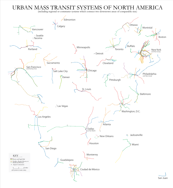
The Urban Mass Transit Systems of North America map (right) created by Yale Professor Bill Rankin on his website Radical Cartography in 2006 presents all of the subway systems in North America at the same scale using geographic, instead of topological, layout. The networks on xkcd's map are displayed with absolutely no consideration to geographic position, in order to connect like-colored routes together. While Vancouver is the most North-West, Mexico City being the most South, and San Francisco the most west, distances are not accurate (in reality, Vancouver is closer to Chicago than to Toronto for example) and cities are often arranged in the wrong direction from one another:
- San Francisco is shown directly west of Toronto - in reality west southwest
- Boston is shown directly north of New York City and just slightly to the west - in reality east northeast
- Atlanta is shown west southwest of Miami - it is actually north northwest
- Atlanta is shown northwest of Mexico City - it is actually northeast
- Atlanta is shown slightly east of being south of Los Angeles - it is actually just slightly north of being directly east
The map's design is modeled after the system map of the Massachusetts Bay Transportation Authority in Boston where Randall is from.
City-specific notes[edit]
Vancouver[edit]
- The Canada Line and the Expo Line are shown as the same color; SkyTrain's official maps depict them with light blue and dark blue respectively.
- Richmond, B.C., is the name of the city where the southernmost terminus of the Canada Line is located, and shares its name with Richmond, California (see San Francisco section).
Boston[edit]
- The "Green Line Extension to Canada" references the actual project to extend the Green Line into Medford, north of Boston, which was completed in 2022.
- The "Ashmont–Manhattan High-Speed Line" shown as connecting Boston's Red Line to New York City's 1 train is a play on the Ashmont-Mattapan High Speed Line in Boston.
- The renamed Red Line stops Skinflower and Bonevine are plays on the actual name of the Red Line's terminus, Braintree.
- The Orange Line terminates at Forest Hills in Jamaica Plain. It is connected to New York's IND Concourse Line, but unfortunately despite its ambiguous appearance on the map this does not actually through-run to the IND Queens Boulevard Line with its Forest Hills and Jamaica stations.
San Francisco[edit]
- Both Muni and BART are depicted in San Francisco's map and are completely separate systems, although the map gives the impression that trains interline between the two. Non-wheelchair-accessible stops on Muni lines are omitted.
- Richmond is the name of the city where the northern terminus of the Richmond–Fremont and the Richmond–Daly City/Millbrae BART lines are located, and shares its name with Richmond, British Columbia (see Vancouver section).
- "Sunnydale" is the actual name of the terminus of the Muni T Third Street line, not to be confused with the city where Buffy the Vampire Slayer is set, nor the very real city of Sunnyvale, located approximately at the location shown, some 40 miles southeast of San Francisco.
Los Angeles[edit]
- The Gold Line and the Orange Line are shown with swapped colors.
- The Orange Line is the only bus rapid transit (BRT) line to be shown on the map. LA Metro also operates a second BRT line, the Silver Line, which is not shown.
New York City[edit]
- The New York City Subway, Port Authority Trans-Hudson (PATH), and the single line of the Staten Island Railway (with a connection via the Staten Island Ferry) are shown.
- Jamaica is the name of the neighborhood in Queens where the E, F, and J/Z trains terminate. Kingston is the capital and largest city in the country of Jamaica.
- The actual G train is notorious for unreliable service, hence the "Random Service" notation.
- The "Robert Moses High-Speed Line" refers to the NYC urban planner Robert Moses, who was one of the most influential planners in supporting cars over all public transport, creating the car-dependent New York metropolitan area.
Philadelphia[edit]
- Both SEPTA subway lines, a portion of the SEPTA Subway–Surface Trolley Lines, and the PATCO Speedline are shown.
- The Norristown High Speed Line and Media-Sharon Hill Lines are not shown
- "Trolley Rt. 10 to California" is a play on the actual Route 10 trolley.
- The West Trenton Line, a commuter rail line, has accidentally ended up in Cleveland for no reason.
Washington, DC[edit]
- The "Graveyard for passengers killed by closing doors" refers to the warning played in the Washington DC Metro system advising passengers that the subway doors are "not like elevator doors" and will close on your limbs or belongings rather than opening when contact with an object is detected.
- The "Morgantown, WV Automated Line" references the Morgantown Personal Rapid Transit system, which was built in 1975 as a personal rapid transit demonstrator and serves the three campuses of West Virginia University.
- Greenbelt is the northern terminus of the Washington Metro's Green and Yellow lines, hence the Green line being depicted as forming a belt.
- This comic was made before the Silver line was constructed, so it does not appear in the comic.
Miami[edit]
- The "Caribbean Metromover" references the Miami Metromover, a people mover in downtown Miami (not shown on the map.)
- The airport logo for Miami International Airport (MIA) is replaced with a paper airplane.
San Juan[edit]
- The "Puerto Rico Submarine" that connects the Red Lines of San Juan and New York refers to the fact that San Juan is on an island, namely Puerto Rico. It is a pun on the Staten Island Ferry, which also has New York at one end, the idea being that there could be a different, comically unlikely sea-faring vessel travelling to Puerto Rico.
- The "Mona Tunnel" that connects the Red Lines of San Juan and Santo Domingo may refer to the island of Mona, which lies between Puerto Rico and Hispaniola.
Monterrey[edit]
- The "Chicxulub Tunnel" that connects the Red Lines of Santo Domingo and Monterrey refers to the 65-million-year-old Chicxulub crater, which lies roughly between the two cities.
Official subway maps[edit]
- Atlanta - http://www.itsmarta.com/rail-schedules-or-route.aspx
- Baltimore (MTA Maryland) - http://mta.maryland.gov/sites/default/files/metro-subway.jpg
- Boston (MBTA) - http://www.mbta.com/schedules_and_maps/subway/
- Chicago (CTA) - http://www.transitchicago.com/assets/1/maps/P19_2012_CTA_Rail_Map.pdf
- Cleveland - http://www.riderta.com/pdf/maps/System_Map_Rapid_Connect.pdf
- Los Angeles (LACMTA) - http://www.metro.net/riding_metro/maps/images/rail_map.gif
- Mexico City - http://www.metro.df.gob.mx/imagenes/red/redinternet.pdf
- Montreal - http://www.stm.info/english/metro/images/plan-metro.jpg
- New York City (MTA) - http://www.mta.info/maps/submap.html
- New York City (PATH) - http://www.panynj.gov/path/maps.html
- Philadelphia (SEPTA and PATCO) - http://www.septa.org/maps/system/index.html
- San Francisco (BART) - http://www.bart.gov/images/global/system-map.gif
- San Francisco (MUNI) - https://www.sfmta.com/maps/muni-metro-map
- Toronto (TTC) - https://www.tourbytransit.com/toronto/public-transit/subway
- Vancouver - http://mapa-metro.com/mapas/Vancouver/mapa-metro-vancouver.png
- Washington (WMATA) - http://wmata.com/rail/maps/map.cfm
Missing cities[edit]
Not all cities with a subway are shown on the map. Missing from the map:
- Pittsburgh (Port Authority of Allegheny County) has a light rail subway tunnel, called The T, in the downtown area. The subway opened in 1985, which is before this comic was published.[citation needed]
- Seattle (Sound Transit) has a light rail called the link light rail has multiple underground tunnels as well as above ground stop. Opened in 2003, there are 3 seperate lines, serving Lynwood, Seattle, and Seattle–Tacoma International Airport on the 1 line, King County Eastside on the 2 line, and Downtown Tacoma and the Tacoma Dome on the T line.
Transcript[edit]
- Subways of North America
- [A subway-line style (bold colored, 45-degree aligned lines with white bars indicating stations) map has been constructed by combining and linking various parts of the subway maps from many different cities, as if all of the transit systems were connected directly. The cities include (from top to bottom, left to right) Vancouver, Montreal, San Francisco, Toronto, Boston, Chicago, Los Angeles, Cleveland, New York City, Philadelphia, Baltimore, Washington DC, Miami, Atlanta, Monterrey, San Juan, Santo Domingo, and Mexico City.]
Trivia[edit]
This comic used to be available as a poster in the xkcd store before it was shut down.
This comic also makes a good map for the Subway Planet in 2765: Escape Speed and the link to xkcd is shown on the planet.
Discussion
I think the comic is making fun of the ridiculous scale-inaccuracies found in public transport plans, including subway plans, which make it hard to estimate actual distances and travel times. 130.60.152.125 (talk) 08:15, 8 April 2013 (UTC) (please sign your comments with ~~~~)
- Well that's because you live in America. They are inaccurate because it makes them easier to read: you should already know the distances between the stops. Beanie (talk) 12:03, 24 May 2021 (UTC)
I think it's deffently a factor. <that one editor who always forgets to login> 82.16.27.115 (talk) 08:35, 8 April 2013 (UTC) (please sign your comments with ~~~~)
- (Let's try again, dodgy internet link, here, and someone's editing in parallel it seems.) I don't personally find the scale-inaccuracies ridiculous. Take a scale-consistent map of a "city-and-its-suburbs" and it's way too busy/cramped in the centre and very sparse at the fringes. Personally I like the way that Moscow treated this problem. But my favourite is of course the classic London Underground maps. Or, for fun, this variant (image link available there, but I've already got a copy on my wall anyway). In fact, what I take from Randall's Subways image is something akin to what I like about this latter. Instead of playing with identity, playing with connectivity. Anyone want to add the Tube/Paris Metro/Berlin U&S-Bahn, etc, onto the edges of Randall's effort? ;) 178.99.244.212
- 'Deffently.' I don't think you have a say here if you spell the word 'definitely' that badly. Beanie (talk) 12:05, 24 May 2021 (UTC)
Evocative (perhaps far too?) of the frontispiece of "Transit Maps of the World". A stylized representation of all of the world's subway maps connected together. 199.167.121.226 18:38, 8 April 2013 (UTC)
What does it mean "(with respect to geography)"? As a non US citizen I don't know what is odd about this map. Is this actually how the lines connect up? Are these real stations/lines? Can you really go from san fransisco to new york on subway? 31.221.13.140 (talk) 09:19, 8 April 2013 (UTC) (please sign your comments with ~~~~)
- Of course not. These are all different subway systems, only connected on this map because their official individual maps use the same colors for different lines. I expect this explanation will be updated to list all the different systems seen here, including Bay Area Rapid Transit (BART) and the New York Subway. 75.37.205.50 09:30, 8 April 2013 (UTC)
- "I expect this explanation will be updated to list all the different systems seen here" As a New Yorker, I can say that while most of the map is quite accurate, some lines cannot be named because each color belongs to multiple lines (with some exceptions) and Randall has taken some serious liberties at the connections to other systems. (E.g. there is no blue line with one end in Hoboken and the other end at 34th Street, as shown on this map) Bdemirci (talk) 12:17, 8 April 2013 (UTC) EDIT: That blue line might be part of the NJ Transit, but including a New Jersey line in with the Subway is quite heretical. Bdemirci (talk) 12:25, 8 April 2013 (UTC)
- That blue line is part of PATH, a subway between NJ and NYC. It's not part of NJ Transit; it's run by the Port Authority, an agency created by a bi-state compact between NY and NJ. And its official map does indeed use blue for the line from hoboken to 33rd street. 66.202.132.250 13:57, 8 April 2013 (UTC)
- I heard they're starting to talk about extending the 7 to Secaucus... 128.220.159.17 15:35, 11 April 2013 (UTC)
- "I expect this explanation will be updated to list all the different systems seen here" As a New Yorker, I can say that while most of the map is quite accurate, some lines cannot be named because each color belongs to multiple lines (with some exceptions) and Randall has taken some serious liberties at the connections to other systems. (E.g. there is no blue line with one end in Hoboken and the other end at 34th Street, as shown on this map) Bdemirci (talk) 12:17, 8 April 2013 (UTC) EDIT: That blue line might be part of the NJ Transit, but including a New Jersey line in with the Subway is quite heretical. Bdemirci (talk) 12:25, 8 April 2013 (UTC)
- Also, the comic is using an extremely loose definition of "subway". (Chicago and Cleveland, for example, do not have anything that would fit a normal, dictionary definition of the word. And no, what they do have is certainly not connected in any case -- unless you count highways, in which case the map is ridiculously incomplete.) Jonadab (talk) 11:17, 8 April 2013 (UTC)
- I don't know about Cleveland, but you're just plain wrong about Chicago. Chicago most definitely has a subway system in the traditional (as well as in the pedantic) sense. 207.229.139.18 22:58, 10 April 2013 (UTC)
- You're definitely wrong about Cleveland as well, although it's little used and not very practical, there is absolutely a subway system. As for connection between Cleveland and Chicago, other than by highway or by train, yes, obviously they are not connected. But there is in fact a subway system in Cleveland that fits the traditional (and pedantic) sense of the word, even if it is not massively used by locals (other than on St. Patrick's day, and other large events) 108.162.215.96 09:46, 20 July 2016 (UTC)
- No it does not lmao. Are you talking about like a hundred yards of the red line that goes underground to reach Tower City? Because that is the entire extent of our "subway." What we have is above-ground passenger rail. Most of it is light rail, partially at-grade (green, blue, waterfront), or bus rapid transit (Healthline), but the red line is fully grade-separated heavy rail, the only line we have. But "grade-separated heavy rail" is not subway. Subway means subterranean. EebstertheGreat (talk) 17:34, 18 May 2025 (UTC)
- It's often hard to realize the distances involved when one is talking about a country or region one is unfamiliar with. In the case of North America, and this semi-fictitious subway system, the distances between the furthest points is about 3,000 miles (about 5,000km); it would generally take about 2 days of highway driving, with no stops, to get from any one end to the opposite other. Randall took real subway maps from different cities, already not to scale, and fictitiously joined them together as if the cities were right next door to each other and really connected. They are not. In most cases, you have to fly, drive, take a bus, or take a regular (non-subway) train if you wanted to go from one city's subway system to another's. -boB (talk) 14:47, 8 April 2013 (UTC)
Hmmm, there is no mention of the 7 or so underground stations in Edmonton, Canada. It is classified as light rail as opposed to heavy rail but still meets the "pedantic rail enthusiasts" definition included under the comic.
Quote: For the pedantic rail enthusiasts, the definition of a subway used here is, with some caveats, "a network containing high capacity grade-separated passenger rail transit lines which run frequently, serve an urban core, and are underground or elevated for at least part of their downtown route." For the rest of you, the definition is "a bunch of trains under a city.220.239.66.60 10:10, 8 April 2013 (UTC)
- I suspect the Edmonton, Alberta system got left out for the same reason as the (similarly sized) Buffalo, NY system got left out. The Buffalo system consists of a single line connecting a dozen or so stations below ground and about 5-6 above ground. It fits the "pedantic rail enthusiasts" definition, with the possible exception of being a "network". But more importantly, since it is a single line, I don't think they color-coded it. Without a color-code, where would it hook into Randal's map? Blaisepascal (talk) 14:14, 8 April 2013 (UTC)
In Montreal, the Longueuil station is misspelled as "Longueil". --Prooffreader (talk) 15:32, 8 April 2013 (UTC)
I don't know the other cities' subway maps well enough, but the NYC map has several jokes in it. The "G" line is listed as having "Random service", which is pretty accurate (it's extremely unreliable). The blue and orange lines in Jamaica (a former independent city now part of the boro of Queens) are listed as coming together in "Kingston", which not in NYC, it's the capital of the island nation of Jamaica. There is a fictional "Puerto Rico Submarine" listed as a complement to the real Staten Island Ferry. The (non-existent) connection from Staten Island NY to DC is listed as the "Robert Moses High speed line", in other words, a freeway such as Robert Moses was known for (presumably I-95, although Moses had nothing to do with that). 66.202.132.250 13:57, 8 April 2013 (UTC)
- Just realized that the green line extending north from Hoboken to "Green" is supposed to be the Green Line of the Hudson-Bergen Light Rail which has elevated and subway segments (the rest of the system is at-grade). The real line ends at the Tonnelle Avenue parking lot in North Bergen. It only has service during weekdays (not nights). 66.202.132.250 14:56, 9 April 2013 (UTC)
- I don't think that's supposed to be the HBLR. If it were, the (larger) part that runs south from Hoboken Terminal would be there too. I think that's just a connection he threw in between green-colored lines. NJT, surprisingly enough for an agency of its size, doesn't have any kind of rapid transit service, so I wasn't expecting to see any of NJT on there. (Except *maybe* the Newark Light Rail, formerly known as the Newark City Subway.) 128.220.159.17 15:35, 11 April 2013 (UTC)
- Strange why the Jay-Z doesn't extend to "Kingston"; they end at Jamaica Center just like the E. Maybe this is a reference to Kingston's actual public transit? I tried looking it up, thinking that maybe Kingston has two subway lines (blue and orange for the E and F), but I got nothing. Bdemirci (talk) 08:27, 10 April 2013 (UTC)
- Speaking of, Randall missed a connection opportunity here since the Orange line of the MBTA ends at "Forest Hills", just like the M in New York. (Maybe because the F keeps going, and there's no way to tell them apart? Plus, it would take an overlap of the lines to match them up.) Bdemirci (talk) 22:17, 10 April 2013 (UTC)
- Well, what the Orange Line continues onto *does* end up going to a Forest Hills... one that's even labeled... 128.220.159.17 15:35, 11 April 2013 (UTC)
Looks like Randall goofed with one of his jokes. West Trenton is one of the final stops on one of Philadelphia's passenger rail lines (SEPTA). SEPTA isn't really a subway as it's only underground in the city center. But he happened to draw it in the "Cleveland" area of the map, and ended up connecting it to Boston's Cleveland Circle. That doesn't make sense since there's no west Trenton in Cleveland. 66.202.132.250 13:57, 8 April 2013 (UTC)
- Philadelphian here. I did a double-take at that one, as I was looking at what Philly's system was hooked up with, then spotted the words "West Trenton" in approximately the same relative position to Philly's subways as it is on the SEPTA map. And then I looked for ways that the West Trenton label might be justified where it is, but I couldn't find any. Also, "SEPTA isn't really a subway" ignores the two real subway lines it does run, plus the subway line run by a separate agency (PATCO) into Philadelphia, plus the subway segment of the trolley lines (which definitely qualify for inclusion if the MBTA Green Line did), all of which are shown. You seem to have been thinking of the commuter rail (Regional Rail) only, which doesn't qualify for the map, period. 128.220.159.17 15:35, 11 April 2013 (UTC)
The comic leaves out the Newark Light Rail (formerly known as the Newark Subway). It's only one line with about 15 stops, but it does connect with the PATH system (which is in the comic) -- JamesCurran (talk) 21:21, 8 April 2013 (UTC) (please sign your comments with ~~~~)
Good couple of jokes in the Boston area: 1) The real station of Braintree is accompanied by the fictional stations of Bonevine and Skinflower; 2) Ashmont-Mattapan High Speed Line has conveniently become Ashmont-Manhattan High Speed Line; 3) The Green Line extension currently under development has been rerouted to Canada; 4) The Cleveland Circle Station has become the departure point for the shuttle to Cleveland. 209.6.46.147 14:26, 8 April 2013 (UTC)
The downtown area has the Caribbean Metromover. It's not visible on this map because by scale, the Metromover system's tiny; the stops are only a couple blocks apart. Its actual shape is similar to the icon on weather maps for a hurricane but mirrored horizontally. There is no mention of the unused ghost station at Government Center, surprisingly. 75.95.79.214 20:32, 8 April 2013 (UTC)
I wasn't aware of a town called Sunnydale in the USA.
However, whilst researching whether this was a pun to the Buffy Television series it turned out the metro station named Sunnydale actually exists: http://en.wikipedia.org/wiki/Sunnydale_Avenue_Station ...
Kaa-ching (talk) 15:44, 8 April 2013 (UTC)
The map shown in this comic is the BART system (Bay Area Regional Transit), not the San Francisco Muni. So, I suspect this is meant as a Buffy reference. Also, Sunnyvale (note the V) is a real town in the SF Bay Area, but it does not have BART service. -- Armckoe (talk) 15:50, 8 April 2013 (UTC) (please sign your comments with ~~~~)
- Nope, Randall conflates both Muni and BART in this (which is what the whole comic is, really...) On the western part of the SF map, the purple is the the L-Taraval, the Green is the M-OceanView , the blue is the N-Judah, the Red appears to be the T-Third, the orange the J-Church. On the eastern side, tho, the chart looks more BART-ish. Hmmm, I'm going to have to take the N-Judah to the end of the line some day (or at least farther along.) I've always wanted to go back to Vancouver. -> 64.7.70.234 04:49, 9 April 2013 (UTC)
- (The Muni route map is here) -> 64.7.70.234 04:49, 9 April 2013 (UTC)
- I don't like how he merged in the Muni lines though. The Muni map (Not Randal's, I mean the real one in the stations) is not accurate to the actual geography of the lines, it is more of an indication of the relative direction the lines run. Also, the Muni map isfar more zoomed in than the Bart map. Both these factors caused Randal's map to have some oddities, like having the Sunnydale station south east of the airport (And somewhere in the bay I would guess).24.5.180.33 08:06, 25 April 2013 (UTC)
Curious that the Sunnydale line connects to San Francisco instead of Los Angeles, considering that the latter is actually depicted in the show and is the setting for the Angel spinoff. 71.211.186.75 00:56, 9 April 2013 (UTC)
- Sunnydale is a real exit along the Muni 'T' line. Also, Buffy's zip code placed here nearish San Jose and Santa Cruz (actually sort of closer to San Jose). This made UC Santa Cruz a possibility for the college they depicted her attending. 24.5.180.33 08:06, 25 April 2013 (UTC)
I'm not sure what prevented the St. Louis MetroLink from making the cut. There are 2 lines (Red and Blue - yes, it's only two, but isn't that still a network?). It's got grade separation in the urban core and other high-traffic areas, it's high-traffic, runs frequently (every 10-20 minutes) and is underground in downtown St. Louis. The only reason I can think of is insufficient grade-separation, but Randall doesn't define a threshold for that. 66.148.130.2 (talk) 16:44, 8 April 2013 (UTC) (please sign your comments with ~~~~)
Pittsburgh Light Rail, or "The T", currently has only 2 lines as well, and parts of it are above ground, but I still would have liked to see it make the cut. It gets heavy usage in downtown Pittsburgh. 24.154.252.235 (talk) 19:53, 8 April 2013 (UTC) (please sign your comments with ~~~~)
The "Morgantown WV Automated Line is clearly a reference to the WVU Personal Rapid Transit system. The PRT goes underground for all of about 15', but the whole lower half is elevated. It's also nice that the area attributed to it is approximately the route the PRT does take. An interesting side note - the PRT is not rails. Its a wheeled system that runs on pavement. http://en.wikipedia.org/wiki/Morgantown_Personal_Rapid_Transit Having said that, I'd also like to echo that the Pittsburgh and Newark subways should have been included. I suspect a v 2.0 in the future. {{98.236.92.146 23:34, 8 April 2013 (UTC)|hewhocaves}}
Atlanta's subway map is found at http://www.itsmarta.com/rail-schedules-or-route.aspx 134.24.147.160 13:53, 9 April 2013 (UTC)Max
I just noticed that the plane icon for the MIA airport is a paper airplane as opposed for the typical icon used for the other airports. Is this a reference to something? 107.205.37.99 18:39, 9 April 2013 (UTC)
- You must not have left the house during all of 2007. I envy you. http://youtu.be/ewRjZoRtu0Y 22:18, 9 April 2013 (UTC)
- Sounds like a reference to the song Paper Planes by M.I.A. (sometimes written MIA), aka Mathangi "Maya" Arulpragasam. I think it is her most popular (in a Billboard sense) so far and has charted in countries scattered all over the world. 129.176.151.14 18:06, 10 April 2013 (UTC)
The Seattle monorail is not a loop, so the "Springfield Monorail" is not a reference to it. Also, Randall neglected to include Seattle's own subway that connects downtown to the airport. 50.46.145.200 05:33, 10 April 2013 (UTC)
I liked seeing something actually acknowledge the existence of the Baltimore Metro Subway. It's one of the best-kept transit secrets in Baltimore - a number of lifelong Baltimoreans I know were quite surprised to learn that Baltimore has an actual subway. (The existence of its light rail is much better known.) The green belt by Greenbelt (a Washington Metro station) was a nice touch - there's really no other natural way to connect the Greenbelt and Johns Hopkins stations without forming a loop like that anyway. I'm not sure how pleased Owings Mills will be at suddenly having West Philly one stop away though... 128.220.159.17 15:35, 11 April 2013 (UTC)
- Are you serious, they grew up there and don't know about it? Where do they live? I guess the Johns Hopkisn station is pretty obscure, and they'd have to never see the other two or so and not live in the northwest but still, don't they have friends or family or acquaintences or TV or talk to people or like trivia at all? To tell the truth one of the first things a normal New Yorker would do upon reaching a new city is see what their subway map's like. One line (almost a half of a line, it ends like 1.7 stops past the city center) and a light rail, that's underwhelming. 108.27.91.16 (talk) 21:22, 12 April 2013 (UTC) (please sign your comments with ~~~~)
Seems like Randall also flubbed the location of YVR in the Vancouver system. Yes, it's the YVR/Richmond line, but Richmond is the one that goes straight down and YVR branches off to the west.174.6.48.164 03:22, 16 April 2013 (UTC)
Laughs in Moscow Metro
XAXAXAXAXAXAXAXAXAX They have SPb-Moscow connection jokes here too! 141.101.95.118 04:54, 3 December 2024 (UTC)