Search results
Page title matches
File:map of the internet.jpg (740 × 1,076 (204 KB)) - 16:46, 20 November 2012
File:map projections.png (650 × 1,990 (241 KB)) - 16:46, 20 November 2012File:Map projections.png #REDIRECT [[File:map projections.png]](650 × 1,990 (241 KB)) - 17:30, 12 August 2012File:Map of the internet.jpg #REDIRECT [[File:map of the internet.jpg]](740 × 1,076 (204 KB)) - 17:50, 12 August 2012
File:Map St Louis to Fermilb.png (821 × 379 (453 KB)) - 20:50, 27 January 2016
File:1653 United States Map 49 piece jigsaw solved.jpg ...isplay that the states in Randall's comic 1653 fit very well with the real map from Wikipedia.(800 × 552 (110 KB)) - 22:15, 12 March 2016
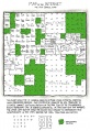
File:map age guide.png (740 × 544 (147 KB)) - 01:53, 30 May 2018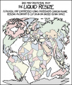
File:bad map projection liquid resize.png (517 × 607 (82 KB)) - 04:49, 11 January 2017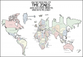
File:bad map projection time zones.png (740 × 508 (62 KB)) - 04:46, 15 February 2017
File:bad map projection time zones 2x.png (1,480 × 1,015 (160 KB)) - 08:59, 15 February 2017
File:1799 Map with Labeled time zones.PNG I created a map overlaid with more obvious time zone divisions, labeled with some of that z ...looks much better than what I had in mind. Would it be OK to download your map to these pages and insert it in the explanation? --[[User:Kynde|Kynde]] ([[(1,480 × 1,015 (469 KB)) - 21:40, 18 February 2017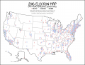
File:2016 election map large.png Large image for comic 1939: 2016 Election Map(2,560 × 1,944 (348 KB)) - 19:16, 8 January 2018
File:bad map projection south america.png (688 × 469 (64 KB)) - 05:02, 17 January 2020
File:bad map projection the greenland special.png (740 × 646 (124 KB)) - 00:52, 15 July 2021
File:flag map sabotage.png (529 × 424 (67 KB)) - 01:31, 14 October 2021
File:bad map projection madagascator.png (740 × 645 (186 KB)) - 16:11, 29 April 2022
File:bad map projection abs longitude 2x.png (1,480 × 1,644 (620 KB)) - 00:30, 27 July 2023


Page text matches
File:Map projections.png #REDIRECT [[File:map projections.png]](650 × 1,990 (241 KB)) - 17:30, 12 August 2012File:Map of the internet.jpg #REDIRECT [[File:map of the internet.jpg]](740 × 1,076 (204 KB)) - 17:50, 12 August 2012
File:amazon.png What's this map that no page on the wiki links to doing here?(491 × 348 (41 KB)) - 13:51, 2 March 2013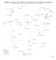
File:North American subways.svg.png * Permission: This map is released under the Creative Commons License 2.0 – you are free to use,(600 × 651 (107 KB)) - 00:50, 25 April 2013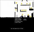
File:hoverboard.png Full Map here: https://codepen.io/KyleDavidE/full/WQBawV(664 × 628 (72 KB)) - 15:44, 31 March 2023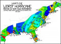
File:xkcd 1407 colored index.png Map from xkcd 1407 colored based on each hurricane's index in the table.(1,280 × 933 (438 KB)) - 12:25, 30 November 2015
File:xkcd 1407 colored millis.png Map from xkcd 1407 colored based on each hurricane's dissipation date, normaliz(1,280 × 933 (436 KB)) - 12:25, 30 November 2015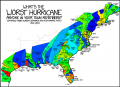
File:xkcd 1407 colored millis smaller.png Map from xkcd 1407 colored based on each hurricane's dissipation date, normaliz(740 × 539 (256 KB)) - 12:28, 30 November 2015
File:xkcd 1407 colored template.png Template for easy coloring of the map from xkcd 1407(1,280 × 933 (50 KB)) - 14:13, 30 November 2015
File:1653-rearranged.png USA Map with states moved to correct locations(800 × 500 (88 KB)) - 17:57, 9 March 2016File:1653 United States Map 49 piece jigsaw solved.jpg ...isplay that the states in Randall's comic 1653 fit very well with the real map from Wikipedia.(800 × 552 (110 KB)) - 22:15, 12 March 2016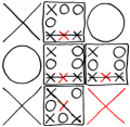
File:Tic-Tac-Toe-X-1-8.png In Map for X, first select cell 1, and then cell 8. This is the same as selecting(226 × 220 (24 KB)) - 17:40, 2 May 2016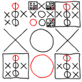
File:Tic-Tac-Toe-O-6-4.png In Map for O, first select cell 6, and then cell 4. This is the same as selecting(229 × 229 (27 KB)) - 18:31, 2 May 2016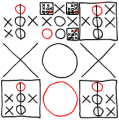
File:Tic Tac Toe-O-6-4.png In Map for O, first select cell 6, and then cell 4. This is the same as selecting(222 × 224 (28 KB)) - 18:34, 2 May 2016
File:challengers subcomic seattle washington.png ...White Hat and Hairbun sitting at an office desk. The presentation shows a map of a district.](720 × 598 (34 KB)) - 18:20, 2 November 2018File:1799 Map with Labeled time zones.PNG I created a map overlaid with more obvious time zone divisions, labeled with some of that z ...looks much better than what I had in mind. Would it be OK to download your map to these pages and insert it in the explanation? --[[User:Kynde|Kynde]] ([[(1,480 × 1,015 (469 KB)) - 21:40, 18 February 2017
File:1799 overlay.png ...//imgs.xkcd.com/comics/bad_map_projection_time_zones_2x.png xkcd #1799 Bad Map Projection: Time Zones](1,470 × 796 (1,024 KB)) - 17:51, 25 February 2017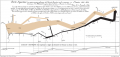
File:Minard.png English: The map's French caption reads: Figurative Map of the successive losses in men of the French Army in the Russian campaign(800 × 381 (206 KB)) - 02:35, 19 April 2017File:2016 election map large.png Large image for comic 1939: 2016 Election Map(2,560 × 1,944 (348 KB)) - 19:16, 8 January 2018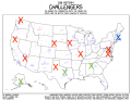
File:Challengers Map.png Map showing location of features for comic [[2067: Challengers]](991 × 770 (267 KB)) - 20:26, 2 November 2018


