#REDIRECT [[1653: United States Map]]
37 bytes (4 words) - 05:17, 9 March 2016
| title = United States Map
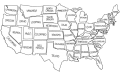
...ext = It would be pretty unfair to give to someone a blank version of this map as a 'how many states can you name?' quiz. (If you include Alaska and Hawai
16 KB (2,606 words) - 15:15, 20 December 2023
But what prompted this map? Has there been a real life event that influenced Randall to create this?
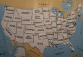
I removed the names from Randall's map! [http://i.imgur.com/Mvi8j9s.jpg Here's a blank version!] Muahahaha! [[User
6 KB (892 words) - 19:43, 15 November 2022
==United States Map==
Reply to your comment on [[1653: United States Map]]:
341 bytes (56 words) - 09:04, 9 March 2016
...ose. A schematic of the human body, for instance, looks more like a subway map with various organs labeled as “air bag,” “blood pusher,” “thinki
4 KB (634 words) - 21:16, 11 November 2022
...ts in cabin - I suspect that modern planes DO have some sort of navigation map there. Failing that, asking tower for flight plan would be not only prefera
...ts for that too, but they are far less sophisticated, might even require a map and a pencil :-) --[[User:Todor|Todor]] ([[User talk:Todor|talk]]) 15:59, 2
12 KB (2,029 words) - 21:27, 15 January 2023
...ks since Randall made a really complicated joke with [[1653: United States Map]] (and a week before that also with [[1649: Pipelines]]). Someone mentioned
16 KB (2,597 words) - 18:43, 10 June 2018
...://www.explainxkcd.com/wiki/images/9/90/1663_garden_Three_colors.png color map]. And that garden I can actually still change here almost a day after, but
32 KB (5,251 words) - 17:14, 4 September 2023
| [[User:MAP|MAP]]
61 KB (10,494 words) - 00:31, 1 March 2024
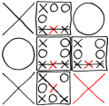 | File:Tic-Tac-Toe-X-1-8.png In Map for X, first select cell 1, and then cell 8. This is the same as selecting
(226 × 220 (24 KB)) - 17:40, 2 May 2016 |
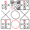 | File:Tic-Tac-Toe-O-6-4.png In Map for O, first select cell 6, and then cell 4. This is the same as selecting
(229 × 229 (27 KB)) - 18:31, 2 May 2016 |
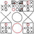 | File:Tic Tac Toe-O-6-4.png In Map for O, first select cell 6, and then cell 4. This is the same as selecting
(222 × 224 (28 KB)) - 18:34, 2 May 2016 |
...s content-aware resizing tool] was a very questionable choice to use for a Map Projection.
12 KB (1,955 words) - 23:09, 31 January 2024
...be adopted consistently. I actually thought of making a template out of my map-table right away, precisely for the purpose of generalizing all US-describi
...I wouldn't say the table format is as appropriate for the world political map. US states are quite same-sized; tabularizing them results in less distorti
12 KB (2,076 words) - 14:10, 6 June 2017
#REDIRECT [[1688: Map Age Guide]]
33 bytes (4 words) - 12:36, 1 June 2016
#REDIRECT [[1688: Map Age Guide]]
33 bytes (4 words) - 12:36, 1 June 2016
| title = Map Age Guide
...ider that seagulls, staplers, tubas, or breadboxes could be mistaken for a map. Randall also mentions US President {{w|Jimmy Carter}} being [https://en.wi
57 KB (8,200 words) - 13:59, 17 April 2024
...are four or five main branches: fictional maps, topographical maps, not a map, and political maps (which have two branches, based on the naming of Istanb
Note that it is very hard to even ''find'' Jan Mayen on an actual world map (even a political one), never mind figure out which country it belongs to.
21 KB (3,174 words) - 23:51, 5 March 2024