Talk:2868: Label the States
I have not counted the states, but I deeply hope reaching the 64-state count involves splitting Michigan's mitten and peninsula in separate states. 108.162.241.130 16:02, 15 December 2023 (UTC)
- I have now counted them. Sadly, with a Unified Michigan, there are 64 states, plus DC, plus those 3 enclave-looking bits in California, Utah and Florida that have the darker outlines. 172.69.214.73 16:09, 15 December 2023 (UTC)
- Those "enclave" parts are large bodies of water that actually exist. MAP (talk) 16:14, 15 December 2023 (UTC)
- I am not at all sure that the areas in California, Utah, and Florida are intended to be additional states. They look like Okeechobee (Lake in Florida), Salt Lake (Utah) and the Salton Sea (California), approximately. There does seem to be an additional band of states starting between Oregon and California though- as a supporter of the Great State of Jefferson, I appove!Seebert (talk) 16:17, 15 December 2023 (UTC)
- They didn't really seem to be; they do have the coastline outlines, instead of the lighter state boundaries. The 64-count did work out without these lakes (though a part of me wishes one of them had been one, because it would have been funny to imply a state formed fully landlocked inside another, and even funnier if that state is just an entire body of water) 108.162.242.38 16:26, 15 December 2023 (UTC)
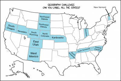
I believe I have identified (but not named) all the new states:
- South of Oregon
- South of Idaho
- South of Wyoming
- East of Montana
- East of Wyoming
- South of the previous new state
- East of Arizona
- North of Tennessee
- North of North Carolina
- East of New Hampshire
Additionally, the following states have been stretch and/or split:
- Colorado
- Nebraska
- Arkansa
- Ohio
The distinction between a split state and a new state is purely arbitrary based on what preserves distinctive state corners. 172.69.214.108 16:35, 15 December 2023 (UTC)
- Personally, would describe the new state as being south of North Carolina. The one to the north better matches the general outline of North Carolina (particularly the Outer Banks and that long, straight northern border). 172.69.247.65 16:58, 15 December 2023 (UTC)
I added locations for the new states in the explanation. If you think my interpretation is wrong, feel free to change it! Trogdor147 (talk) 16:49, 15 December 2023 (UTC)
Could this be considered in a "series" with other maps like the mixed up states and left out states ones? 162.158.158.233 17:19, 15 December 2023 (UTC)
Not sure if it's relevant but the number of 64 (as a power of 2) doesn't seem completely random. Could be a hint towards states in the computer science sense. You could use 6 bit to represent any number of states up to 64 - and you'd already need 6 bit for the actual number of US states.172.69.22.129 17:40, 15 December 2023 (UTC)
someone with better photoshop skills than me should overlay the normal map and point out the inconsistencies! Mushrooms (talk) 17:51, 15 December 2023 (UTC)
- Overlaying the maps goes beyond my skills with Paint, but I hope showing the real map and xkcd's one with extra states highlighted is clear enough.--Pere prlpz (talk) 18:08, 15 December 2023 (UTC)
Labeled all… INCLUDING Central Dakota, Central Carolina, North Arkansas, West Mexico, Kansorado, Ohindiana, Kentussee, Eyoming, East Hampshire, North Wyoming, West Dakota, South Oregon, Udaho, and Montanyoming. TenGolf MathHacker (talk) 18:53, 15 December 2023 (UTC)
- I propose instead that the state north of Colorado be Wyoming, the one to the west become Wyamping, and the one to the north become Wyvolting. 172.71.22.132 19:01, 15 December 2023 (UTC)
My proposal (hope the image is fine):

