Difference between revisions of "2868: Label the States"
m (Add bullets) |
Trogdor147 (talk | contribs) (→Explanation: Added locations for all new states) |
||
| Line 17: | Line 17: | ||
* Ohio has been split into two states with a new north-south border in the middle. | * Ohio has been split into two states with a new north-south border in the middle. | ||
* A new, Tennessee-shaped state has been added between Tennessee and Kentucky. | * A new, Tennessee-shaped state has been added between Tennessee and Kentucky. | ||
| + | * Additionally, a new, North Carolina-shaped state has been added between Virginia and North Carolina. | ||
| + | * A square-shaped state has been added between Arizona and New Mexico. | ||
| + | * Another rectangular state has been added between North and South Dakota (Middle Dakota?). | ||
| + | * An Arkansas-esque state has been added between Arkansas and Missouri. | ||
| + | * New Hampshire now has a state that looks like its reflection between itself and Maine. | ||
| + | * Four rectangular states have been added between Montana, Wyoming, and Colorado and the Dakotas, Nebraska, and Kansas. | ||
| + | * Another rectangular state has been added between Colorado and Wyoming. | ||
| + | * Lastly, another rectangular state has been added between Idaho, Utah, and Nevada. | ||
==Transcript== | ==Transcript== | ||
Revision as of 16:46, 15 December 2023
| Label the States |
 Title text: Even with a blank map, a lot of people can only name 45-50 of the 64 states. |
Explanation
| |
This explanation may be incomplete or incorrect: Created by a LEONIDA MAN - Please change this comment when editing this page. Do NOT delete this tag too soon. If you can address this issue, please edit the page! Thanks. |
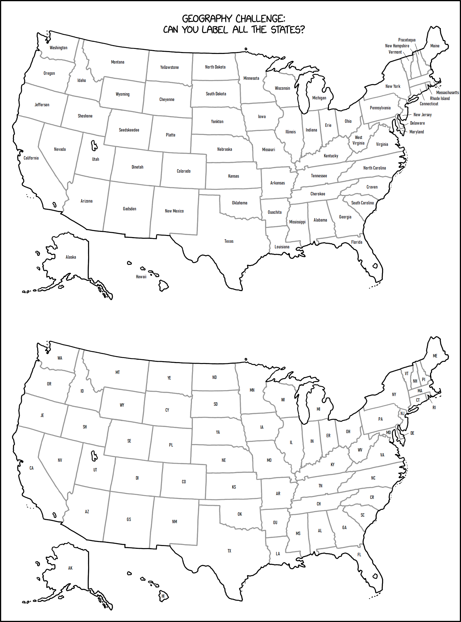
This is a blank map of the United States. At first glance, it looks correct, because all the large states with distinct shapes are correctly represented, but some states have been added. For example:
- On the west coast, Washington, Oregon, and California all have their normal shapes, but there is a new rectangular state south of Oregon and north of California.
- Ohio has been split into two states with a new north-south border in the middle.
- A new, Tennessee-shaped state has been added between Tennessee and Kentucky.
- Additionally, a new, North Carolina-shaped state has been added between Virginia and North Carolina.
- A square-shaped state has been added between Arizona and New Mexico.
- Another rectangular state has been added between North and South Dakota (Middle Dakota?).
- An Arkansas-esque state has been added between Arkansas and Missouri.
- New Hampshire now has a state that looks like its reflection between itself and Maine.
- Four rectangular states have been added between Montana, Wyoming, and Colorado and the Dakotas, Nebraska, and Kansas.
- Another rectangular state has been added between Colorado and Wyoming.
- Lastly, another rectangular state has been added between Idaho, Utah, and Nevada.
Transcript
| |
This transcript is incomplete. Please help editing it! Thanks. |
- Geography Challenge:
- Can you label all the states?
- [An unlabeled map of the United States, but instead of 50 states, there are borders for 64.]
Discussion
I have not counted the states, but I deeply hope reaching the 64-state count involves splitting Michigan's mitten and peninsula in separate states. 108.162.241.130 16:02, 15 December 2023 (UTC)
- I have now counted them. Sadly, with a Unified Michigan, there are 64 states, plus DC, plus those 3 enclave-looking bits in California, Utah and Florida that have the darker outlines. 172.69.214.73 16:09, 15 December 2023 (UTC)
- Those "enclave" parts are large bodies of water that actually exist. MAP (talk) 16:14, 15 December 2023 (UTC)
- I am not at all sure that the areas in California, Utah, and Florida are intended to be additional states. They look like Okeechobee (Lake in Florida), Salt Lake (Utah) and the Salton Sea (California), approximately. There does seem to be an additional band of states starting between Oregon and California though- as a supporter of the Great State of Jefferson, I appove!Seebert (talk) 16:17, 15 December 2023 (UTC)
- They didn't really seem to be; they do have the coastline outlines, instead of the lighter state boundaries. The 64-count did work out without these lakes (though a part of me wishes one of them had been one, because it would have been funny to imply a state formed fully landlocked inside another, and even funnier if that state is just an entire body of water) 108.162.242.38 16:26, 15 December 2023 (UTC)
- Should have been Salt Lake, if any of them, mostly because its closer to being "salt flats" than a "lake." And also nearly completely valueless as real estate (I've driven through, I forgot to fill my gas tank before leaving the city and in order to reach the nearest gas station I had to drive 10 miles to the next exit in order to turn around, because the tiny village the exit was for didn't have a gas station). Draco18s (talk) 21:25, 16 December 2023 (UTC)
- They didn't really seem to be; they do have the coastline outlines, instead of the lighter state boundaries. The 64-count did work out without these lakes (though a part of me wishes one of them had been one, because it would have been funny to imply a state formed fully landlocked inside another, and even funnier if that state is just an entire body of water) 108.162.242.38 16:26, 15 December 2023 (UTC)
I believe I have identified (but not named) all the new states:
- South of Oregon
- South of Idaho
- South of Wyoming
- East of Montana
- East of Wyoming
- South of the previous new state
- East of Arizona
- North of Tennessee
- North of North Carolina
- East of New Hampshire
Additionally, the following states have been stretch and/or split:
- Colorado
- Nebraska
- Arkansa
- Ohio
The distinction between a split state and a new state is purely arbitrary based on what preserves distinctive state corners. 172.69.214.108 16:35, 15 December 2023 (UTC)
- Personally, would describe the new state as being south of North Carolina. The one to the north better matches the general outline of North Carolina (particularly the Outer Banks and that long, straight northern border). 172.69.247.65 16:58, 15 December 2023 (UTC)
I added locations for the new states in the explanation. If you think my interpretation is wrong, feel free to change it! Trogdor147 (talk) 16:49, 15 December 2023 (UTC)
Could this be considered in a "series" with other maps like the mixed up states and left out states ones? 162.158.158.233 17:19, 15 December 2023 (UTC)
Not sure if it's relevant but the number of 64 (as a power of 2) doesn't seem completely random. Could be a hint towards states in the computer science sense. You could use 6 bit to represent any number of states up to 64 - and you'd already need 6 bit for the actual number of US states.172.69.22.129 17:40, 15 December 2023 (UTC)
someone with better photoshop skills than me should overlay the normal map and point out the inconsistencies! Mushrooms (talk) 17:51, 15 December 2023 (UTC)
- Overlaying the maps goes beyond my skills with Paint, but I hope showing the real map and xkcd's one with extra states highlighted is clear enough.--Pere prlpz (talk) 18:08, 15 December 2023 (UTC)
Labeled all… INCLUDING Central Dakota, Central Carolina, North Arkansas, West Mexico, Kansorado, Ohindiana, Kentussee, Eyoming, East Hampshire, North Wyoming, West Dakota, South Oregon, Udaho, and Montanyoming. TenGolf MathHacker (talk) 18:53, 15 December 2023 (UTC)
- I propose instead that the state north of Colorado be Wyoming, the one to the west become Wyamping, and the one to the north become Wyvolting. 172.71.22.132 19:01, 15 December 2023 (UTC)
My proposal (hope the image is fine):
 Mushrooms (talk) 20:00, 15 December 2023 (UTC)
- You've labeled Nebraska as a "new" state for some reason, and it looks like it's been added to the actual description. Someone really ought to fix that. 172.71.154.118 08:24, 16 December 2023 (UTC)
Here's my take. [1] N-eh (talk) 20:02, 15 December 2023 (UTC)
- This is absolutely delightful, Hyperbolic Kansas is my favorite Terdragontra (talk) 15:15, 18 December 2023 (UTC)
- I just got the joke... oh my goodness it's perfect. Trogdor147 (talk) 00:23, 8 February 2024 (UTC)
Loving the state name proposals. Here's mine. Chasingballoons (talk) 21:16, 15 December 2023 (UTC)
- I liked N-eh's names better, except for "Occupied South Oregon and New Worchestershire". Those are truly inspired names.
I'm sorry to burst your bubble, but what you have labelled as Kansbraska is actually just Nebraska. Just south of Nebraska is the new state, which I'd tentatively name Nebrahoma or perhaps Oklaska.
The image with the added states highlighted in the explanation has Nebraska highlighted. The correct state highlighted should be the one above Nebraska. guess who (if you want to | what i have done) 22:35, 15 December 2023 (UTC)
- The image history just flips between South Dacota (with notch in NE) and Nebraska (with inward corner in SW), without ever marking the new state between them. One half each of Arkansas and Ohio disappeared too. There will probably be some more iterations with similar edit collisions... :D Anyways, the maps are aesthetically pleasing. Good job! --162.158.87.205 14:32, 16 December 2023 (UTC)
Very proud of everyone here for somehow managing to edit war over which states to highlight and getting it wrong Four Times In A Row IloLisipo (talk) 17:31, 16 December 2023 (UTC)
- It's really bothering me that Colorado is currently marked in blue as a new state, when it seems rather obvious by the distorted outlines that "East Utah" (the one entirely West of Texas) is the "new" one... (Also, is no one going to make a Garfield joke about Wyoming being a made-up state?)
- ProphetZarquon (talk) 02:06, 17 December 2023 (UTC)
- Clearly, the state next to New Mexico is Newer Mexico.
Based on historical precedent, should the state south of Oregon and north of California be called Jefferson?
I think currently the real Tennessee and Arkansas are highlighted. It's hard to tell, but given that the new states tend to be aligned, the real Colorado might also be highlighted. This comment is about the fifth version of the highlighted map image. DL Draco Rex (talk) 18:56, 17 December 2023 (UTC)
- I agree, & it looks like the only thing delaying the corrections already called for, is that no one has wanted to do the image editing, to update the blue tiles in the explanation.
- ProphetZarquon (talk) 22:21, 17 December 2023 (UTC)
- Well, given that I've seen no objections over the past roughly a day, I went ahead and did it myself. Someone else can change the explanation text if it needs to be changed. DL Draco Rex (talk) 18:27, 18 December 2023 (UTC)
- Cool, now I fully agree with the highlights. Thanks Draco! (Now waiting for someone to highlight Arkansas, so we are back at the initial version. :D) --162.158.87.164 14:46, 20 December 2023 (UTC)
- *Nebraska—You know, I am an european... --162.158.87.164 14:50, 20 December 2023 (UTC)
- Cool, now I fully agree with the highlights. Thanks Draco! (Now waiting for someone to highlight Arkansas, so we are back at the initial version. :D) --162.158.87.164 14:46, 20 December 2023 (UTC)
- Well, given that I've seen no objections over the past roughly a day, I went ahead and did it myself. Someone else can change the explanation text if it needs to be changed. DL Draco Rex (talk) 18:27, 18 December 2023 (UTC)
Any comment on the use of the word "even" in the title text? That phrasing suggests that it's easier to name the states with a blank map. But that obviously makes it harder, not easier. And also, if the map weren't blank there would be no need to name them in the first place. Barmar (talk) 02:37, 18 December 2023 (UTC)
- It's easier to name the States with a blank map as opposed to no map at all. DL Draco Rex (talk) 04:59, 18 December 2023 (UTC)
- Yup, if asked to "name all the states", unless you particularly have an order in mind (that you can remember, through some mnemonic progression or other) you're prone to stabbibg away at the unordered list, not knowing if you've missed an 'obvious' one, perhaps not even knowing how many you've named, etc. Put an (unlabeled) map in front of you and a pen and you can general see which gaps you've filled (hopefully correctly, but when you realise that you wqnt to fill a neighbour with the same name then you can at least rewrite it/accept that you might have North Dakota/South Dakota the wrong way round but at least you have them both) and zero in on likely bits of memory you need to trawl through ("...another 'southern' state; I've got Arkansas, I've got Tennessee, I've got...").
- Depends upon your own mind (maybe you're a whiz at reciting all states alphabetically/by abbreviation/by area/by population/by support for a given party or politician), but definitely can't hurt. (Unless you miss Rhode Island's small footprint, or get confused about the discontinuity of that one state up in the Great Lakes, or have managed to shuffle the mid-west flyover 'square states' up or down one to leave the gap in totally the wrong place, or ...) 172.71.242.211 13:15, 18 December 2023 (UTC)
Of course I can name all the states. Naming them correctly is a completely different matter, of course. (And as for naming the "new" states, it's obvious to me that the one beside Maine should be called Secondary.) --172.69.214.5 13:34, 18 December 2023 (UTC)
- "Fred", "Bob", "Dan", "Gregory", "Janine", "Hans", "Merryweather", "Caroline", "Jo", "Joe", "Joey", "Jock", "Jack", "George", "Geraldine", "Jerry", "Gerry", "Gary", "Gru", "Gerald", "Gerald Ford", "Henry Ford", "Henry Kissinger", "Henry Hoover", "Henry Dyson", "Henry Electrolux" "Electra", "Oedipus", "Œdipus", "Wikipædia", "FriendsReunited", "anon.penet.fi", "capitals" "LOWERCASE", "Mississippibutwithdoubledvowelsandsingleconsonants", "Fifty-first state", "Old Hampshire", ",", "Z00000L", "xxTattered Pig-Tail Vestxx", "Fred's cousin", "It was the best of times, it was the worst of times. [...] It is a far, far better thing that I do, than I have ever done; it is a far, far better rest that I go to than I have ever known.", "sic[sic]", "🤮", "ibid", "Ra Ra Rasputin", "Russian Queen", "Rush Limbaugh", "Rishi Sunak", "Randall"
- ...and, though it isn't a state, "Washington A.C."! 172.71.242.178 14:03, 18 December 2023 (UTC)
Is Maine the only state which actually became larger in this version of the US map? --Raviolio (talk) 15:31, 31 January 2024 (UTC)
Friends reference
Should the episode of Friends be referenced in explanation in which Ross tries to name all states or he doesn't get Thanksgiving Turkey and eventually comes in the middle of the night to eat with list of 50 states while aware Nevada is there twice? Meanwhile Joey's list way more than 50 states and accuses Ross of making stuff up as he listed 'Utah'? Script of episode: https://www.livesinabox.com/friends/season7/708cdld.htm 162.158.103.162 09:37, 18 December 2023 (UTC)
- I, uh, think this might be a bit of a reach. DL Draco Rex (talk) 00:38, 24 December 2023 (UTC)
Are the right states highlighted?
I could be wrong, but I think this page currently identifies the real Colorado, Wyoming, and Tennessee as "new" states. The states where Colorado and Wyoming should be with respect to Utah are more accurate proportionally to those states, and the more southern of the two Tennessee-like states just looks more like Tennessee to my eyes. Squee333 (talk) 03:14, 29 December 2023 (UTC)
- I disagree strongly. The real Tennessee is a quadrilateral. The upper Tennessee is a quadrilateral. The lower one is not. It also makes absolutely no sense for that random state to be the real Wyoming. Look how much cleaner the previous version is. You can see how states were slid apart to fit new states. You can't just look at proportions, you also need to consider positions. I strongly suggest reversion. 172.71.167.201 13:14, 31 December 2023 (UTC)
- I was partially going off of the discussion here: https://www.reddit.com/r/xkcd/comments/18j9nnb/the_bonus_14_states/. I'll change it back, but looking at a real map I'm not entirely convinced.
New State Name Proposals and Abbreviations
Tried to come up with serious-sounding names while including some proposed states and native people in order to determine what to call certain regions. View Map Feel free to make your own edits, or tell me to edit it if you want the style to be consistent. Note that I’m not dead-set on the placement of Tennessee/Cherokee and Arkansas/Cahokia or the Cherokee/Cahokia abbreviations. CatboyNiko (talk) 06:01, 10 January 2024 (UTC)CatboyNiko
- Your "Central Dakota" is the real South Dakota, and your South Dakota is actually the new state. Arkansas is AR, and Nebraska is NE. US states actually can't have the same abbreviations as Canadian provinces; Alberta is AB. Since these states would have gotten their abbreviations before the Canadian provinces if they actually existed, you might want to change the names. I won't comment any further about the controversy surrounding which states are actually AR, CO, TN, and WY... Squee333 (talk) 22:50, 12 January 2024 (UTC)
- I'd probably do this: https://raw.githubusercontent.com/Squee3/Misc/main/label_the_states_2x_highlighted.png. Names that don't match yours are from here: https://www.alternatehistory.com/forum/threads/return-of-horrible-educational-maps.375167/page-293. Squee333 (talk) 16:52, 15 January 2024 (UTC)
- Whoops! State abbreviations are hard. Here’s the updated map with your suggestions and one with your amendments labeled. CatboyNiko (talk) 11:38, 3 February 2024 (UTC)CatboyNiko
- When I click on your new maps, I get "This content is no longer available."... Squee333 (talk) 01:54, 11 February 2024 (UTC)
- I've come up with a new set of names for you that I think might work better: https://raw.githubusercontent.com/Squee3/Misc/main/label_the_states_2x_highlighted.png Names mostly have historical precedent where possible. Squee333 (talk) 19:43, 19 February 2024 (UTC)
- Here's mine: https://imgbox.com/OmT0Zuq6
- Name Origins: Dineta is the Navajo homeland -- it could replace either Gadsen or Nuuchi. The Yankton are part of the Dakota, so this makes it so there are (secretly) three Dakotas. Nuuchi is the endonym of the Ute. Seedskeedee is Shoshone for the Green River. When the province of Carolina was split in twain OTL, the new provinces were named after two of the lords proprietary, the Earl of Clarendon and the Duke of Albemarle. The Earl of Craven was another lord proprietary. JackBonhomie (talk) 02:47, 25 February 2024 (UTC)
- Great suggestions! Used them (except for Franklin, since the new state is apparently the southern one, and Quapaw, since they weren't on the AR/LA border) here: https://raw.githubusercontent.com/Squee3/Misc/main/label_the_states_2x.png Squee333 (talk) 20:19, 25 February 2024 (UTC)
- I've come up with a new set of names for you that I think might work better: https://raw.githubusercontent.com/Squee3/Misc/main/label_the_states_2x_highlighted.png Names mostly have historical precedent where possible. Squee333 (talk) 19:43, 19 February 2024 (UTC)
- When I click on your new maps, I get "This content is no longer available."... Squee333 (talk) 01:54, 11 February 2024 (UTC)
- Whoops! State abbreviations are hard. Here’s the updated map with your suggestions and one with your amendments labeled. CatboyNiko (talk) 11:38, 3 February 2024 (UTC)CatboyNiko
- I'd probably do this: https://raw.githubusercontent.com/Squee3/Misc/main/label_the_states_2x_highlighted.png. Names that don't match yours are from here: https://www.alternatehistory.com/forum/threads/return-of-horrible-educational-maps.375167/page-293. Squee333 (talk) 16:52, 15 January 2024 (UTC)
Iʼm surprised no one suggested “Nebraskota” for the new state between Nebraska and South Dakota. Heleatunda (talk) 19:24, 13 April 2024 (UTC)
